Free Satellite Data Is a Commodity. Intelligence Is Not.

Here is a quiet contradiction in the PropTech and geospatial space: free satellite data is celebrated as a democratizing force that levels the playing field for startups. And it is. USGS Earth Explorer, ESA Copernicus Sentinel, NASA Earthdata, Google Earth Engine. Eighteen platforms now offer free, unrestricted access to decades of optical and radar imagery covering every square meter of Earth. The entry barrier that once required eight figures of capex is gone.
Yet geospatial startups are not flooding the market. The ones winning are not the ones who celebrated free data loudest. Something shifted. The democratization was real. But it moved the competitive boundary.
The Free Data Stack, Concretely
Let me walk through the concrete platforms, because the mental picture most people have is a bit confused.
USGS Earth Explorer gives you Landsat archive going back to 1972. Thirty years of 30-meter resolution multispectral bands, entire footprint free and downloadable. ESA Copernicus runs Sentinel-1 (synthetic aperture radar, all-weather, day-night, excellent for flood mapping) and Sentinel-2 (optical, 10-meter resolution, excellent for vegetation and water indices). Both are free, both are operational rather than archival, and both produce global coverage every 5 to 10 days. Google Earth Engine wraps all of this plus MODIS (daily global coverage) and lets you run analytical workflows on their cloud infrastructure without downloading gigabytes to your laptop. NASA Earthdata is the discovery layer for everything NASA operates. Maxar Open Data released a massive archive of high-resolution imagery (30 to 50cm) specifically for disaster response.
The access problem is solved. You can build a satellite-based product on a zero capex imagery budget.
From this free baseline you can calculate NDVI (vegetation health, comparing red and near-infrared bands from Sentinel-2, entirely free to derive), NDWI (surface water, also Sentinel-2, no license required), and inundation via SAR coherence loss on Sentinel-1, which gives all-weather flood detection through clouds and at night. Every fundamental geospatial analytical technique is now operationalizable on free data.
The entry barrier is gone. So why haven't 200 geospatial startups launched?
Because data without context is noise.
The Differentiation Problem
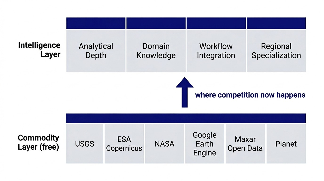
Eighteen months ago, a geospatial startup's competitive moat was data access. You had imagery. Competitors did not. That moat evaporated. Everyone has imagery now. So the competition moved.
The new moat is analytical depth, workflow integration, and domain specialization.
Consider building a flood risk product for Malaysian insurance companies. Sentinel-1 can detect inundation automatically. But inundation from what? A 1-in-100 year event? A 1-in-10 year event? That requires calibration to local hydrological models. Which models does JPPH recognize? Which flood zones does BNM use when calculating exposure? Which property classification system does your insurer operate in?
You can have perfect satellite data and still produce a useless answer because you did not integrate the intelligence layer.
The product is not "we have satellite data." The product is satellite data, plus hydrological knowledge, plus regulatory knowledge, plus integration into the underwriting workflow that changes the decision. That is a layer you cannot download for free.
A Historical Pattern
I saw this before with financial data. In the 1970s and 1980s, trading firms hoarded market data. Bloomberg terminals were expensive. Reuters was exclusive. Information asymmetry was the edge. By the 1990s, every trader had access to the same market feeds. CME, NASDAQ, LIFFE all published real-time data. Suddenly everyone had numbers. And suddenly the edge was not having the data. The edge was having a better model and the discipline to execute on it.
The traders who won were not the ones who celebrated data democratization. They were the ones who spent years developing frameworks for interpreting data in their domain. Forex traders needed to understand central bank signalling, carry curves, geopolitical risk. Equity traders needed to understand sector dynamics, earnings quality, capital allocation. The data was table stakes. The differentiation was interpretation.
Satellite data is entering that same phase.
This pattern runs through most 0 to 1 product work. The infrastructure democratizes. The moat moves up a layer. The builders who understand which layer the competition now happens on are the ones who avoid building undifferentiated products. I wrote about a similar dynamic in Scope Compression and 0→1: the constraint is rarely technology access, it is usually clarity about where the defensible layer actually sits.
The Practical Implication for Builders
If you are building a geospatial product, four things change.
First, the freemium model becomes genuinely viable. You can offer a free tier that demonstrates real value using public satellite data. Show investors and users that you understand their problem and have a point of view. Then charge for the proprietary intelligence layer on top: the regional flood models, the integration with regulatory databases, the workflow optimization for the specific user context.
Second, technical depth becomes less of a differentiator than it was. Everyone can process Sentinel-2 now. The skill floor rose. What differentiates is domain knowledge. If you are building for Malaysian property insurers, do you understand JPPH land classification? Do you know what BNM actually requires for exposure reporting? That is harder to acquire than learning how to run a spectral index calculation.
Third, integration with existing workflows is table stakes. A property developer does not want to learn GIS. They want to open a tool, see a flood risk score, understand what it means for their project. The UI/UX and workflow design are the product, not the satellite processing.
Fourth, there is a real opportunity in regional specialization. If you focus on Malaysia, you can build deeper integration with local regulatory frameworks, local flood models, and local user contexts than a global platform ever can. That specificity is a moat.
The Quiet Advantage
Free satellite data removes the entry barrier for capital-constrained founders. You can bootstrap. You can demonstrate traction without a fundraise. You can build to profitability.
But the barrier to differentiation rose. Now you are competing not just on imagery access but on analytical depth, domain knowledge, and integration quality. That is a different kind of hard. It is hard in a way that rewards specialization, patience, and domain expertise. It is hard in a way that favors practitioners who understand the regulatory context deeply.
For founders, this is good news and bad news together. Bad news: you cannot win by being "the startup with satellite data." That is table stakes. Good news: if you have deep domain knowledge in a specific region or vertical, you have a real advantage. The free data baseline combined with specialized knowledge is a powerful combination.
Geospatial intelligence is no longer a technology problem. It is an interpretation problem. The tools are free. The insight is rare.
What does your satellite analysis do that someone downloading the same Sentinel scene cannot replicate in a weekend? That question, answered honestly, is your product strategy.
Strategy and technology are the same decision. Over 15 years in fintech (CTOS, D&B), prop-tech (PropertyGuru DataSense), and digital startups, I have built frameworks that help founders and executives make both moves at once. Based in Kuala Lumpur.
Working on a 0→1 product?
I help founders and operators go from idea to validated product. Let's talk about yours.
Get in touch →